
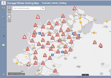
Following Status Yellow weather warnings issued from Met Eireann, Donegal County Council are reminding road users to check their Winter Gritting map which is an interactive map that is linked to the Council’s social media platforms and provides information on routes and length of routes to be gritted on any given night as well as an hourly forecast feed for most areas of the county so that users can check their local weather forecast for the next 12 to 24 hours. It also shows locations where sand and grit stock is available for use by the public.
Road users can also view live road conditions at a number of locations around the county and across the northwest via the Councils website. Locations include N56 at Gaoth Dobhair, N15 at Bundoran, N 15 at Lough Mourne, N15 at Killygordon, N13 at An Grianan Aileach, A515 Foyle Bridge and A6 at Glenshane Pass.
These resources have been developed over the last number of years with a view to providing road users and motorists with the necessary information to make safe driving decisions during the winter months.
According to Met Eireann, from Wednesday showers will turn wintry in many places with falls of sleet and snow expected especially on higher ground.